With over 900 miles of hiking trails, Yellowstone National Park has plenty of beautiful terrains to explore on foot.
There’s a trail for every experience level and age group from stroller-friendly boardwalk trails abound the colorful geysers near Old Faithful to challenging mountain summits that offer rewarding views of the pristine landscape below.
Pack your backpack, grab your camera, and don’t forget the bear spray. These are the 10 best hikes in Yellowstone National Park you won’t want to miss!
The Best Hikes in Yellowstone for All Levels
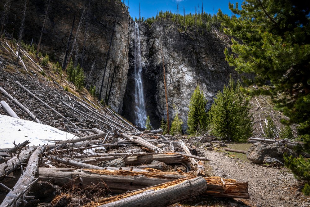
Fairy Falls
Distance: 2.5 miles (5 miles return)
Trail type: Out-and-back
Estimated time to complete: 3-5 hours
Difficulty: Moderate
Elevation gain: 250 feet
Who doesn’t love a scenic waterfall hike in Yellowstone? Fairy Falls is arguably the m ost beautiful waterfall in Yellowstone National Park, but lesser-known than Tower Falls, Upper Falls, and Lower Falls of the Yellowstone.
Fairy Falls is most commonly accessed from the Midway Geyser Basin near Grand Prismatic. To hike to Fairy Falls from the Midway Geyser Basin, park in the Fairy Falls Parking Area about 1 mile south of the geyser basin parking.
From the parking area, cross the bridge over the Firehole River and follow signs to Fairy Falls. After about a half-mile of hiking, you’ll be rewarded with a beautiful overlooking view of the Midway Geyser Basin including Grand Prismatic.
This is a perfect spot to stop for photos! The Yellowstone hike to Fairy Falls is about 2.5 miles each way, with under 250 ft of elevation gain. Once you arrive at the falls, you’ll be blown away by the water’s free fall from 200 ft above!
Before you head into the park, check with a park ranger or online for trail conditions. The Fairy Falls Trail is closed in the springtime for bear management.
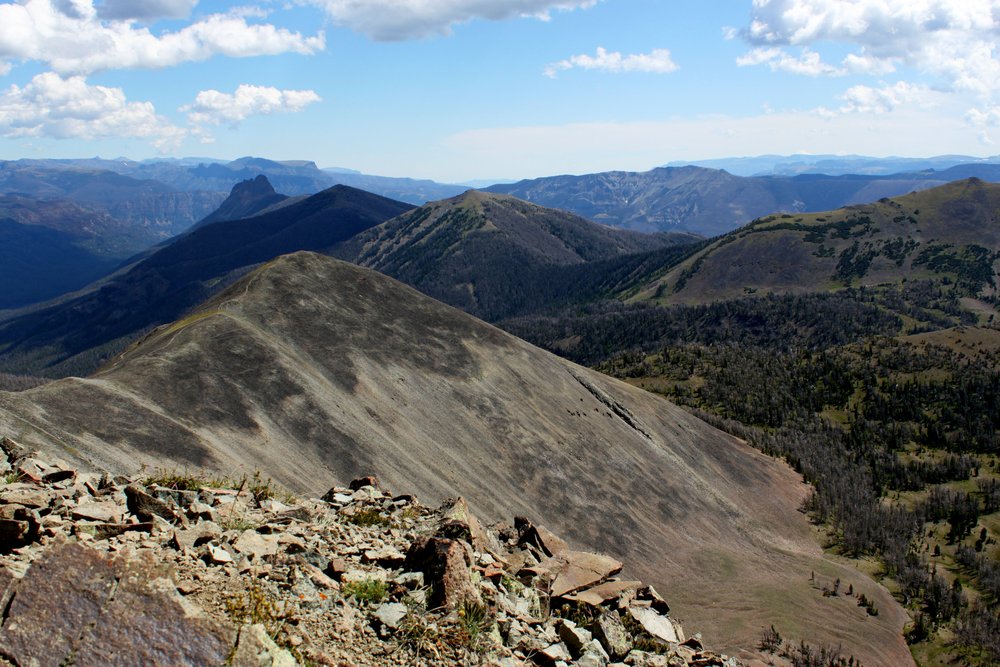
Avalanche Peak
Distance: 2.1 miles (4.3 miles return)
Trail type: Out-and-back
Estimated time to complete: 3-4 hours
Difficulty: Difficult
Elevation gain: 2,100 feet
Extraordinary views of Yellowstone Lake, remote wilderness, and towering alpine peaks wait at the summit of Avalanche Peak.
At 10,574 ft high, Avalanche Peak is a challenging Yellowstone hike fit for experienced hikers with tolerance to steep terrain and high elevation.
One of Yellowstone National Park’s more physically demanding day hikes is also one of the most rewarding.
Roundtrip, this tough Yellowstone hike is about 4.3 miles. In the first 2.1 miles heading to the summit, the elevation gain is a whopping 2,100 ft!
The switchbacking trail that leads to the summit offers stunning views the entire way.
This trail is not recommended during September or October as grizzly bear activity heightens in the months leading up to their winter hibernation. Always hike in groups, make noise, carry bear spray, and be bear aware whenever hiking in bear country.
Winter is also not recommended due to high levels of snowfall.
Uncle Tom’s Trail
Note: Temporarily closed: check here for updates or check AllTrails trip reports for up-to-date information.
Distance: 0.6 miles (1.2 miles return)
Trail type: Out-and-back
Estimated time to complete: 30 minutes – 1 hour
Difficulty: Easy in length, but lots of stairs, so more like moderate for those with bad knees/mobility limitations
Elevation gain: 350 feet
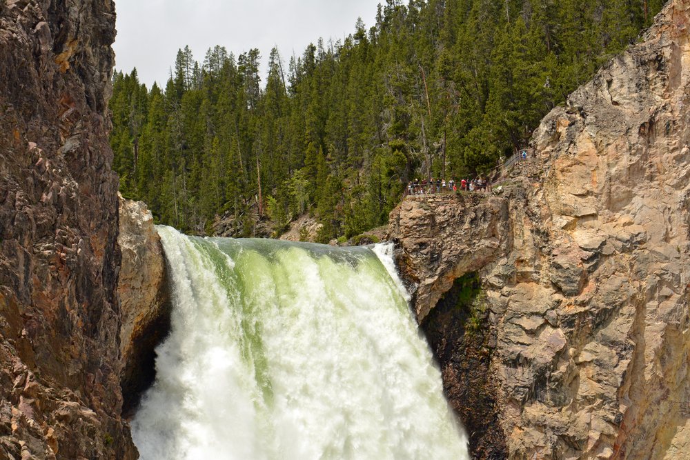
The view from the observation deck at the base of the Lower Falls of the Yellowstone is a must-see for anyone visiting Yellowstone National Park.
Located in the Canyon Area at the South Rim, this heavily trafficked trail takes hikers from the top of the canyon down 328 steps to the base of the Lower Falls, which is a towering 308 ft high!
The hike down into the canyon is no problem with the well-crafted staircase, but keep in mind you’ll have to climb back out. There are many comfortable places to rest on the return hike, and it’s not a race to the finish.
The original trail, constructed by Uncle Tom Richardson in the 1800s, was not as you see it today. Before the well-constructed series of staircases and switchbacks, the trail was made primarily of rope ladders, which brought hikers down to the base of the falls.
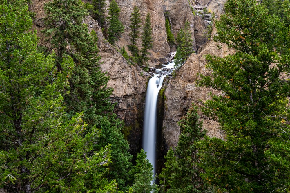
Tower Fall Overlook
Note: At time of writing, this beloved Yellowstone hike is closed. Check AllTrails data for recent updates to see if it’s opened back up!
Distance: 0.9 miles (1.8 miles return)
Trail type: Out-and-back
Estimated time to complete: 1 hour
Difficulty: Easy/Moderate
Elevation gain: 250 feet
Check out the epic 132 ft drop of Tower Creek from the Tower Fall Observation Point! The waterfall is ominously framed by towering pinnacle rock formations, which give the creek its name.
Access to the observation point is very convenient! From the roadside parking area, head towards the trailhead, which is just past the general store.
There’s a popular overlook that’s a short walking distance from the parking area and another that involves covering a little more effort. The second viewpoint includes a 1-mile round trip walk down to the Yellowstone River towards the bottom of the falls.
Unfortunately, the trail ends short of the waterfall’s base due to a mudslide in 2004, but the riverside walk is enjoyable and scenic.
Reward your little hike with a treat from the general store!
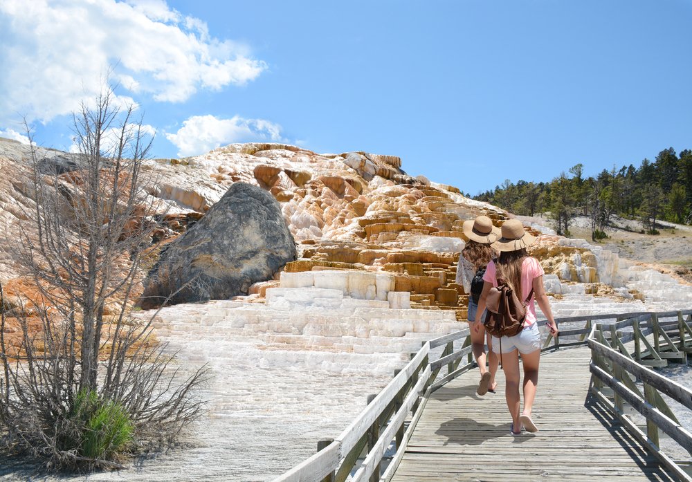
Mammoth Hot Springs Trail
Distance: 3.5 miles
Trail type: Loop
Estimated time to complete: 2 hours
Difficulty: Moderate
Elevation gain: 560 feet
If you were hoping to see elk and hot springs, Mammoth is the place to be! Located nearby the North Entrance and Roosevelt Arch, Mammoth Hot Springs is a great place to get an up-close look at hot springs and even spot some wildlife!
Walk along the series of boardwalks through the variety of hydrothermal features.
Choose to stay on the Mammoth Terraces Trail to explore the Upper and Lower Terraces, which are filled with steamy multi-colored hot pots, or use this trail to access a web of remote backcountry hiking trails.
In total, there are about 1.3 miles of boardwalk available to explore around the Mammoth Hot Springs, plus the traditional trails.
There is parking at the Upper Terrace area, however, the parking area at the Lower Terrace is larger making finding a space much easier!
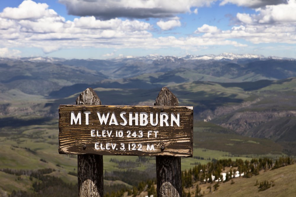
Mount Washburn
Note: This route may be closed — check AllTrails in advance to see if it’s changed
Distance: 3.1 miles one way (6.2 miles return) if coming from Dunraven Pass trailhead
Trail type: Out-and-back
Estimated time to complete: 3-6 hours
Difficulty: Strenuous
Elevation gain: 1,400 ft
If you’re looking to bag a peak in Yellowstone National Park, Mount Washburn is one of the most popular summits and day hiking destinations!
The summit has panoramic views of Yellowstone’s pristine landscape, but that’s not all. The peak also has an active fire lookout, which includes interesting interpretive exhibits.
There are two trails to the summit of Mount Washburn. The first option begins out of the Dunraven Pass Trailhead and is 6.8 miles roundtrip. The second option begins at the Chittenden Road Trailhead and is the shorter route option at 5.8 miles roundtrip.
Both trails offer beautiful scenery and access to the 10,243 ft summit of Mount Washburn. Whichever trail you choose to pursue, be sure to pack all the Yellowstone day hiking essentials including food, water, layers, a trail map, and bear spray.
Keep your eyes peeled as you hike, trail users often report seeing bighorn sheep close to the summit!
Lamar River Trail (Cache Creek Trail)
Distance: 3.5 miles each way, 7 miles return
Trail type: Out-and-back
Estimated time to complete: 3-5 hours
Difficulty: Moderate
Elevation gain: 700 ft
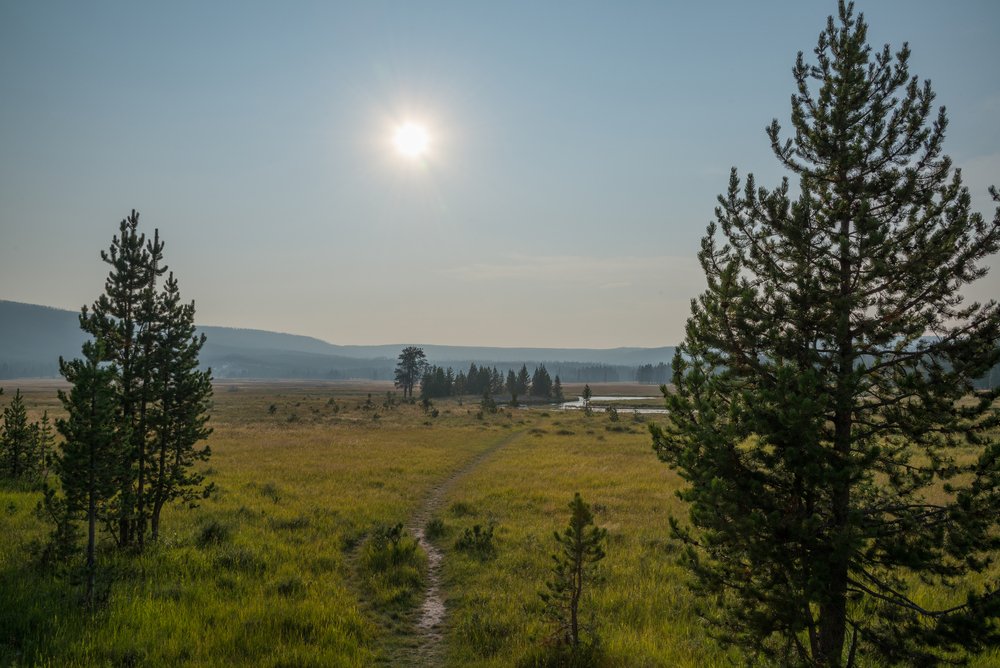
The Lamar Valley is famous for its wildlife sightings and pristine prairie landscape.
While driving through the valley, it’s not uncommon to spot giant herds of bison, wolves patrolling in the hills, or a grizzly bear lumbering around the willows near the river. When visiting Yellowstone National Park, make a visit to the Lamar Valley a high-priority!
Although a drive-by view of the Lamar Valley is nice, an in-depth excursion on foot is even better!
Take one of the best hikes in Yellowstone on the Lamar River Trail/ Cache Creek Trail to explore the area’s rolling landscape, wildflowers, and wildlife. Hikers commonly see herds of bison along the way. Don’t forget to monitor the trail ahead to see who’s footprints have been left in the mud!
Begin your hike into the Lamar Valley at the Lamar River Valley Trailhead and follow the trail toward Cache Creek. The roundtrip distance is around 7 miles with about 700 ft in elevation gain.
Pro tip: Stop often and scan the hillsides using a spotting scope or binoculars to find wildlife. It can be difficult to spot wolves and bear from a distance without one of these tools since they blend so well with the landscape!
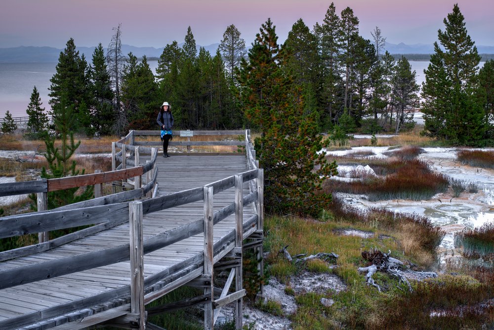
West Thumb Geyser Basin Trail
Distance: 1 mile
Trail type: Loop
Estimated time to complete: 30 minutes
Difficulty: Easy
Elevation gain: 60 ft
Located on the West Thumb of Yellowstone Lake, the West Thumb Geyser Basin Trail is a great spot to stretch your legs and enjoy a picnic lunch.
The boardwalk trail here is a 1-mile loop that sees lots of use in the summertime. With the astonishing views, there’s no wonder why!
The West Thumb Geyser Basin Trail takes hikers along the shores of Yellowstone Lake for a closer look at the fascinating hydrothermal features. Stroll the boardwalk and take in the alpine views from this magnificent trail.
Old Faithful Geyser Loop Trail
Distance: 0.7 miles
Trail type: Loop
Estimated time to complete: 20 minutes
Difficulty: Easy
Elevation gain: 15 ft
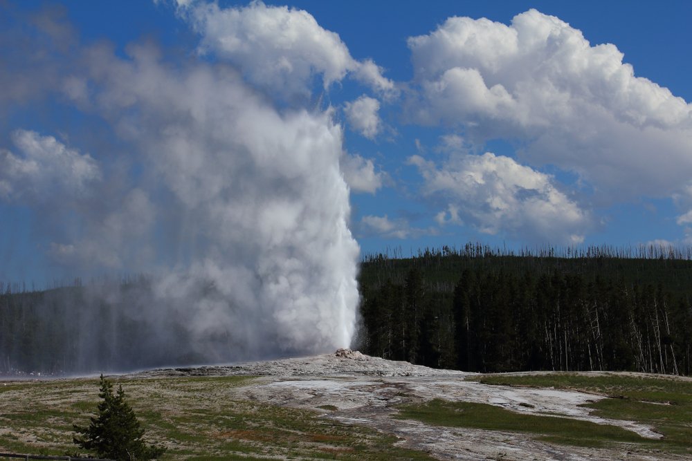
Watching the timely eruption of Old Faithful is often high on Yellowstone National Park visitor’s bucket list. Many arrive at Old Faithful without realizing how much hiking there is to do in the area!
The Old Faithful Geyser Loop Trail is the perfect short Yellowstone hike to do if you have a little time to spare before the big event! At only 0.7 miles roundtrip, this trail is a nice boardwalk stroll for any experience level.
Pass by the colorful pools and bubbling pots as you make your way around the loop. Watch the time! You’ll want to be back to the Old Faithful Viewing Area with time to grab a seat for the eruption.
Old Faithful Pro Tip: If you’re not interested in watching Old Faithful from the bleachers near the visitor center with everyone else, make your way over to Observation Point in time for the event.
To get to Observation Point, find the trailhead at the end of the boardwalk near the Old Faithful Lodge and Old Faithful Lodge Cafeteria. Follow the trail about 0.75 miles to an obvious lookout area.
Remember to be mindful of the natural landscape when choosing a viewing spot. Stay on the maintained trail and avoid stepping on the fragile alpine vegetation.
***
I hope these tips helped you plan some fantastic Yellowstone hikes for your upcoming trip!
Pin These Best Hikes in Yellowstone!
Emily is a freelance travel and outdoor recreation writer from Big Sky, Montana. Her adventurous spirit has led her to the high peaks of the Sierras and the largest wilderness areas in the lower 48. When she’s not writing, Emily can be found backpacking, road tripping to outdoor destinations, climbing, or rowing whitewater.