

8 Incredible Hikes in (and Near) Austin, Texas
Many people visit Austin for the food and music scene.
After all, the city is home to Franklin’s Barbeque, South by Southwest (SXSW), and putting a positive spin on being “weird”.
Nightlife is one of Austin’s biggest draws for visitors. The nightlife scene in Austin includes a thriving gay scene and is one of the most LGBTQ-friendly cities in Texas!
One thing people may not take into account though when thinking about Austin is just how many outdoor activities there are to do, especially hiking trails.
In fact, going for a hike is one of the things you must do in Texas! Austin is located along the Colorado River and sits at the tip of Texas Hill Country.
Since the city sits at four major ecological intersections, it gives adventurers a different experience for each hike they take.
Here are some of the best easy day hikes near Austin!
Best Hikes Near Austin
Mount Bonnell
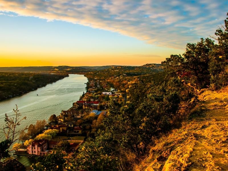
The perfect hike to get us started on the list of awesome Austin hiking destinations is Mount Bonnell. At 775 feet, it is the highest spot in the city.
Don’t let this height intimidate you though, because the hike is relatively easy — only a third of a mile long. The workout for this one comes from the 200-foot elevation gain!
Given that it looks down on the city, this is a perfect view for sunset, though you won’t be alone to enjoy it. If you are an early bird, the sunrise is far less crowded.
Ann and Roy Butler Hike-and-Bike Trail at Lady Bird Lake
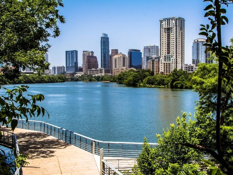
The fourteen and a half-mile trail is perfect for someone looking for unique scenery along their trail run or long, leisurely walk.
Instead of running through just nature, this trail runs through downtown, neighborhoods, and cultural attractions such as Congress Bridge: yes, that famous bridge where you can see bats fly out at sunset!
Another unique feature is the boardwalk, created in 2008 to bridge the gap between several of the trails and make it easier for hikers and runners to enjoy.
St. Edwards Park
This one is one of the lesser-known hikes near Austin, but it definitely worth your time, especially if you are a sucker for waterfalls and nature.
Of the three Austin hikes we have covered so far, this one is the most difficult. Part of the reason for this is that the trail is a bit rocky and hilly.
You have the option of taking the three and a half mile hike or connecting to either the Forest Ridge or Bull Creek trail for a longer route. Choosing one of the longer routes means exciting views that don’t require quite as steep hike as Mount Bonnell!
Interestingly enough, the north side of the park is a part of the city of Austin, while the south side is owned by Balcones Canyonland Preserve system. When going into the Preserve area, it is important to note that dogs must be on their leash.
Shoal Creek Trail
This three and three quarter mile trail consists of many different types of terrain, including concrete, dirt, and gravel. This is in part thanks to the fact that it is the oldest of the hiking trails in Austin, dating back to the 1960s.
Like the Ann and Roy Butler trail, this one is also in the heart of downtown Austin; unlike the previous trail, Shoal Creek is typically less crowded.
This might be in part because instead of giving you city scenery, you feel like you are out in the woods. There is a great deal of shade here, so this one is a good option for warmer sunny days (and are a lot of those in Austin!).
This peaceful Austin hike winds along with a creek, taking you through two parks and even through a canyon towards the northern end of the hike, giving a peaceful backdrop to guide your workout. Despite not having city views, this is one of the Austin hiking trails you don’t want to miss!
Barton Creek Greenbelt
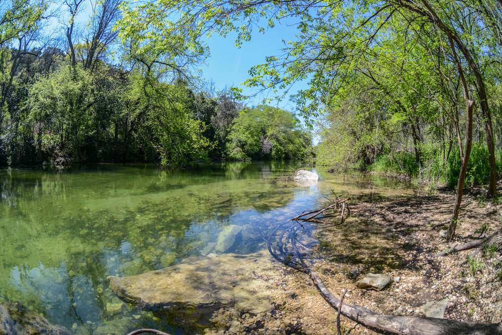
This Austin hike is for everyone! Located in South Austin, there are twelve miles of trails to check out.
If, like me, you are an outdoor enthusiast, there are many other ways you can expand your time along this trek. Other activities you can participate in include hiking, biking, rock-climbing, bouldering, swimming, or even just resting in a hammock.
To get started, the best place to park is Zilker Park. While you have to pay for parking and it does get busy, it starts you off on your first mile and a quarter with fairly flat terrain.
For some of the route, you need to be considerate because it does go through residential neighborhoods. One of the more popular stops includes Gus Fern where, after a good rain, people go for a good, free swim in deeper waters.
The Loop 360 access point is one of the most popular ones throughout the loop because mountain bikers and rock climbers come for the more interesting terrain and the climbing wall Seismic. Something to keep in mind though is it can get rather noisy from the highway located nearby, so it’s not the most relaxing part of the trail.
If you’re looking for an extra challenge on your Austin hike, be sure to check out the Hill of Life! It is a three hundred-foot vertical uphill with some spectacular views and takes about thirty minutes to go up, if you’re going at a decent pace.
McKinney Falls State Park
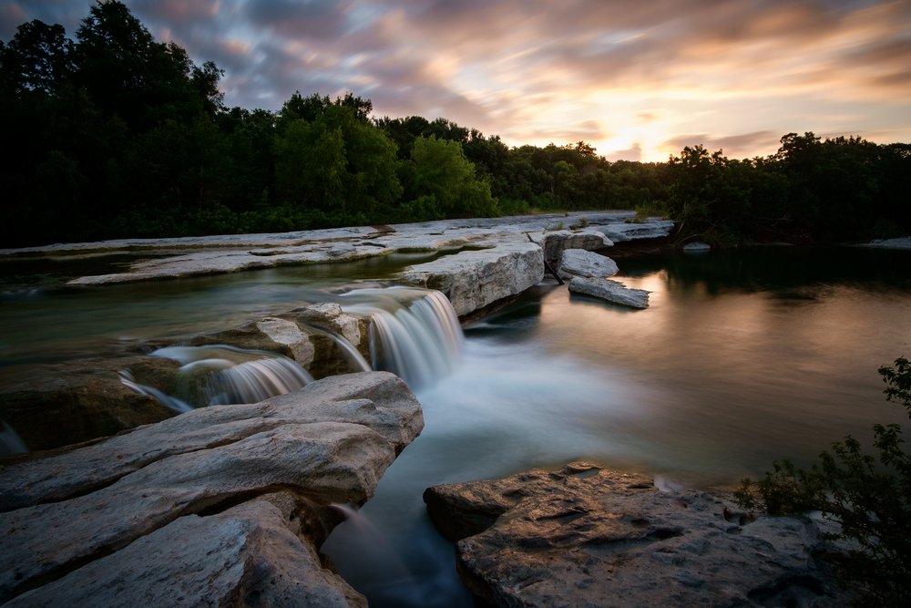
McKinney Park is one of my favorite places. This state park is located 14 miles from downtown, so it’s a perfect hike near Austin if you are looking for a short drive to get away from the city scenery.
There are six different hiking trails along the state park and they range from half a mile to a little over three miles. You can access information about each hike here.
I do want to note, though, that there are some pretty interesting things to see here, including the remains of Thomas McKinney’s horse trainer’s cabin and a picnic table that was donated by the Smith family, who gave the land to the state to build the state park that it is today. They also have done guided events in the past, though I am not sure if they are currently (especially due to present health concerns!).
Unlike previous Austin hikes I’ve listed, which are all free, this one cost $6 to get into if you’re over thirteen. If you are bringing kids along that aren’t yet teenagers, it is free for them. I recommend going in the spring to this trail because the wildflowers are in abundance along the trails, not to mention the cooler weather!
Enchanted Rock State Natural Area
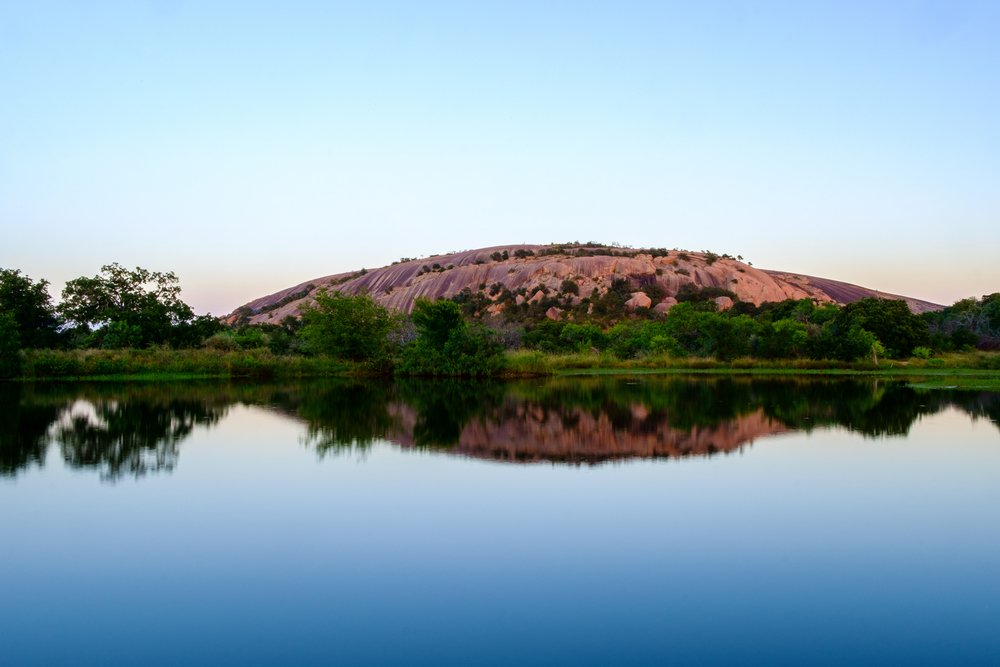
This hiking trail is located the furthest away from Austin, in the town of Fredricksburg, which is about an hour and a half east.
This is also the only one that I would recommend taking advantage of their camping option.
The reason for this is that the natural area is on the list for International Dark Sky Places, meaning there is no light from other areas obscuring your view of the night sky and it is breath-taking, to say the least. They even have ranger-led star parties!
If you’re a stargazing enthusiast, this should definitely be on your Texas bucket list.
There are eight trails to choose from, which range from just over one-tenth of a mile to four miles, with the latter giving you amazing views. The summit of the large rock is 1,823 feet high, and it will definitely get your heart pumping due to the steep incline!
When heading down, you truly get the best view by taking the west side, where the Enchanted Rock meets the Little Rock.
Naturally, in the summer, many people come earlier in the day to shelter themselves from the heat and sun’s rays, since this trail doesn’t offer much shade. I personally think this trail near Austin would be best in fall or spring!
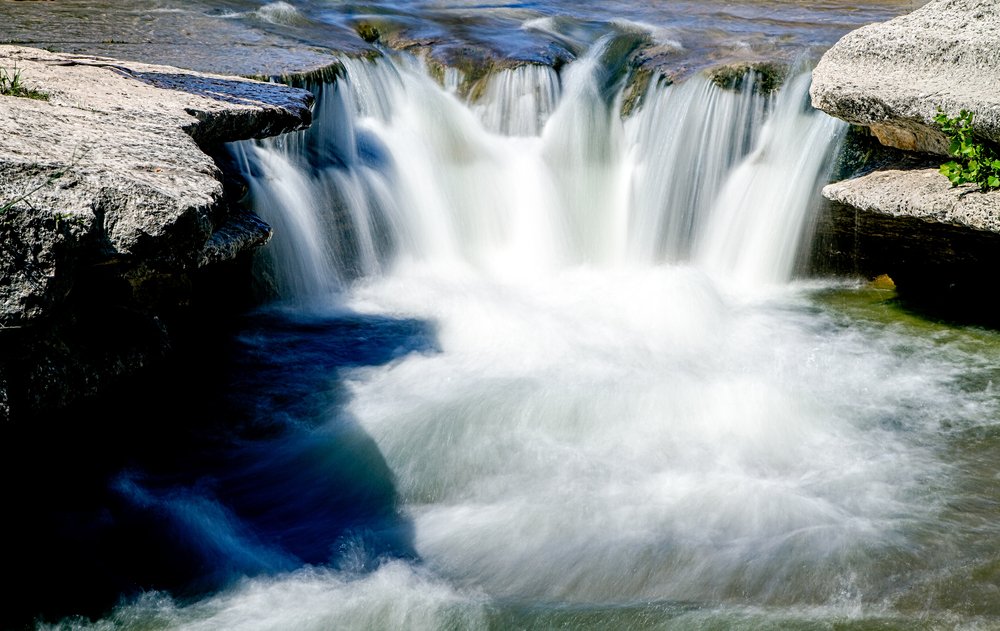
Hamilton Pool Preserve
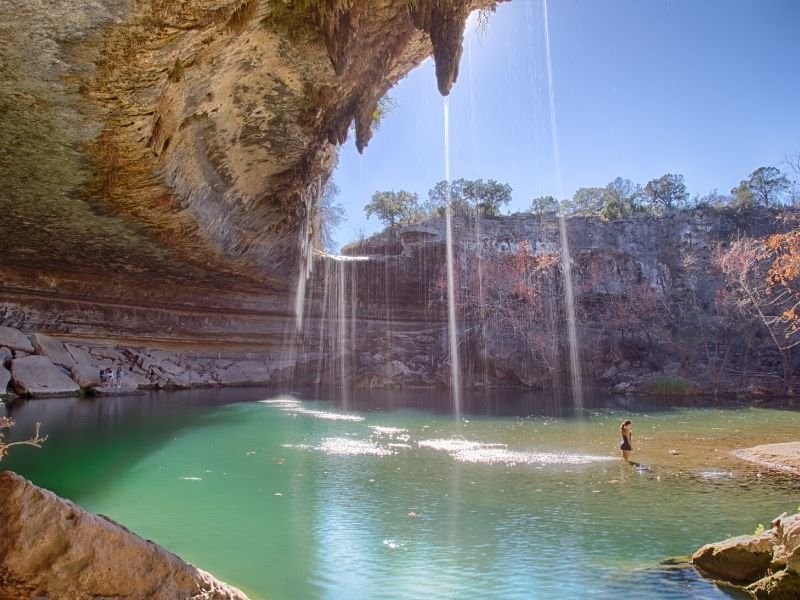
This one was saved for last on purpose! It is very well-known and with good reason.
The location, located thirty minutes outside of Austin, is best known for its beautiful 50-foot waterfall and natural pool area, which is actually a collapsed grotto! Unlike with many of the other trails, this grotto’s water stays consistent all year round.
The trail is not a long one to reach the pools — only about half a mile — but it can be rocky and steep at times so come prepared. Wear proper shoes and not flip flop type sandals.
If you’re looking for more than just spending several hours at a pool, be sure to check out the trail that will take you to the Pedernales River. While you’re hiking, you can search for several birds that are hard to spot in other parts of the state, including the Golden Cheek Warblers and Cliff Swallows.
The cost to get into Hamilton Pools is twofold. First, you have to pay $12 online per car (each car can hold up to eight people). Then you have to pay $8 per person between 13 and 62, $3 for seniors, and it’s free for children under 13.
It is also recommended you book several months in advance, especially in the summer! Part of the reason for this is that you are given a time slot: either 9 AM to 12:30 PM or 2 PM to 5:30 PM. Within that time slot, only 25 people can come in. This is nice because the pool doesn’t get overcrowded (especially important these days!).
Which Austin hike sounds best to you?
Given Austin’s proximity to so many different types of nature, this list of hikes in and near Austin could go on; however, this is a great start and a way to find beauty in the everyday while you spend time in, and around, the Austin area.
Be sure to let us know how you enjoyed the hike and give some tips to your fellow Austinite hikers!
Tiffany is a culinary teacher by day, writer by night. She spends her free time drinking coffee and planning the next big adventure around the United States with her family. Their latest project involves converting an NV1500 work van into a home on wheels.
Mount Bonnell sounds awesome. Putting it on my bucket list Thanks for great info!
Awesome, enjoy!