

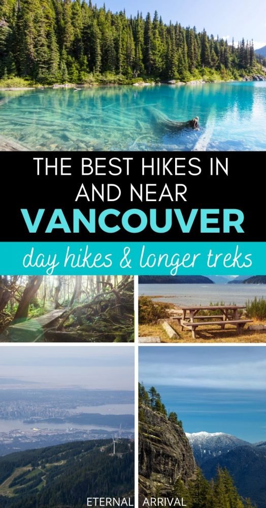
8 Epic Hikes In & Near Vancouver: From Day Hikes to Longer Treks
The city of Vancouver is located in the Lower Mainland region of British Columbia in Canada.
The city’s mild climate and location surrounded by ocean, mountains, rivers, and lakes make the area a popular destination for outdoor activities with fantastic hiking trails near Vancouver.
Downtown Vancouver is in close proximity to the North Shore Mountain range and the Garibaldi Mountains with some excellent mountain scenery and spectacular lakes to explore.
The largest island off the west coast of North America, Vancouver Island, has fantastic coastal hiking trails through spectacular old-growth forest and long stretches of trails right on the beach with the opportunity to see marine animals such as whales, orcas, dolphins and more!
When staying in downtown Vancouver in the center of the city you are close to several amazing forest and mountain trail hikes near Vancouver that can be reached by the local public transport system such as the Grouse Mountain, Lynn Headwater Park, Quarry Rock, and the Baden Powell trail.
A short drive from the city, also within reach by public transport there are several challenging backcountry wilderness mountain trails such as hiking to Garibaldi Lake and The Stawamus Chief.
The Best Day Hikes in Vancouver
Grouse Mountain
Grouse Mountain located about 15 minutes by public transport from Downtown Vancouver. It is a beautiful mountain close to the city center rising 1250 meters (4100 feet) above the city.
The mountain is a popular location for outdoor activities inside the city with fantastic ski runs and facilities for snow sports in winter and home to the challenging Grouse Grind hiking trail and several other exhibitions and entertainment on the mountain in summer.
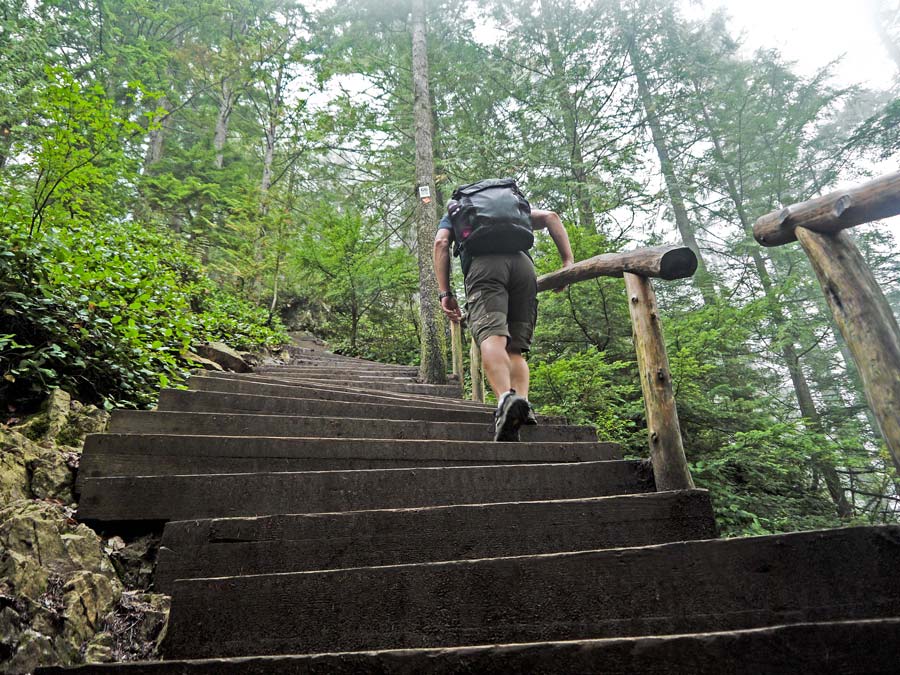
The Grouse Grind trail has quite a reputation when it comes to hiking in Vancouver, as it’s known as one of the toughest challenges the city can throw at you! It is a steep hiking trail up Grouse Mountain with about 3000 stairs climbing 853 m (2800 feet) vertical over a distance of 2.9 km (1.8 mi).
It is a one-way trail; you can only go up the mountain hiking the Grouse Grind and have to go down using the Skyride Gondola for $15 CAD for the ride down the mountain.
The other option is to hike down with a steep trail with some technical parts called the BCMC trail. The Grouse Grind only takes about one and a half to two hours on average to reach the top, but it is a steep hike. Grouse Mountain is easily reached by a shuttle from Canada Place in Downtown Vancouver, making it one of the easiest to get to hikes in Vancouver.
Lynn Headwater Park
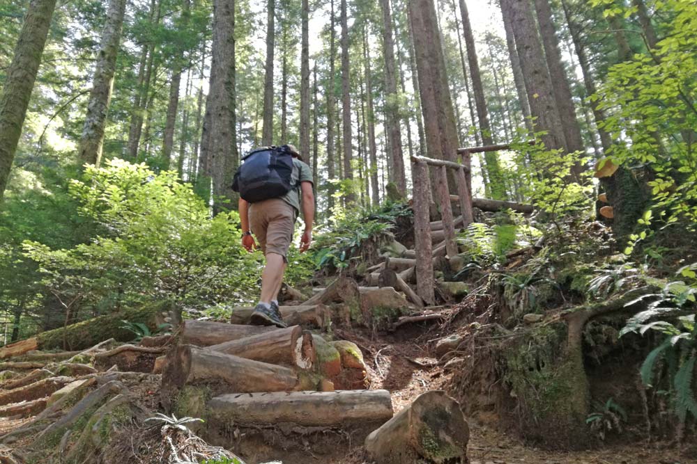
The beautiful Lynn Headwaters is a massive regional park located in the city of Vancouver with 74 km of hiking trails for all skill levels to explore.
The trails in the park vary from easy flat routes to more difficult backcountry trails including more uphill and even some scrambling. It is amazing to find such beautiful forests located inside the city, making it possible to actually go hiking in Vancouver and not just near it!
The Lynn Headwater Park is easy to navigate to by public transport from Downtown Vancouver: a quick ride with the sea bus, and from there, bus #228 goes all the way to Lynn Valley Center.
The Lynn Loop is an easy, fairly flat 5.2 km trail passing through a forest filled with Cedar and Hemlock trees and next to the running water of Lynn Creek. The route is well-marked and the trail is wide and easy to follow.
The Headwater trail is a longer trail at 14km: not too steep, but a bit more challenging.
For a harder climb, attempt the Lynn Peak trail, a steep climb with an elevation change of 720m over 4km. This trail is often compared to the Grouse Grind and takes about 4 hours to complete with epic views of Vancouver and Mount Seymore rewarding you at the end of a tough Vancouver hike!
Baden Powell Trail
The Baden Powell trail is a challenging 48 km trail connecting Deep Cove with Horseshoe Bay on Vancouver’s North Shore.
There are a lot of steep climbs with a total ascent of 4860 m over the route. To hike the complete trail, you need a full day, as there is nowhere to camp on the route.
The trail does however have several parts that can be reached easily, so you can hike different parts of this trail, so you don’t have to do the whole stretch in one go if that’s too intimidating.
The four sections of the trail commonly hiked are: Deep Cove to Lynn Valley, Lynn Valley to Grouse Mountain, Grouse Mountain to Cypress Mountain and Cypress Mountain to Horseshoe Bay.
The trail from Lynn Valley to Deep Cove goes from Lynn Valley park, starting at the Lynn Canyon Suspension Bridge, a beautiful 50m high suspension bridge, a popular free alternative to see the well-known (and expensive) Capilano suspension bridge. This part of the Baden Powell trail passes several beautiful landscapes, including views of Deep Cove, the Seymour River, and Lynn Creek.
The Quarry Rock trail in Deep Cove is an easy 3.8 km hike with beautiful views. Quarry Rock is a large rocky outcrop with amazing views close to the ocean in Deep Cove. The trail overlaps with the Baden Powell trail.
Epic Hikes Near Vancouver & On Vancouver Island
Garibaldi National Park, Whistler
Garibaldi National Park is a wilderness park between Whistler and Vancouver on the coastal mainland. The park gets its name from the glacier-ringed Mount Garibaldi located inside its borders.
This spectacular park is amazing for hiking near Vancouver, with more than 90 km of excellent trails clearly marked, leading you to some of the most beautiful glacial lakes and viewpoints in British Columbia.
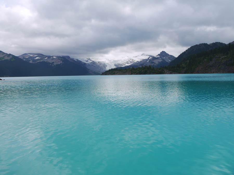
The trail winding to the amazing Garibaldi Lake at an elevation of 1450 m is a bucket list hike to do in the park! The hiking trail is an 18 km out and back route and takes on average 6 hours to hike. This perfect turquoise glacial lake hedged by beautiful mountain peaks makes for unreal views.
The lake is a great place for a swim during this strenuous walk. It is possible to extend the route by hiking to either Panorama Ridge or the Black Tusk peak.
Both these hikes are long day hikes and are often done as backpacking trips camping either at Garibaldi Lake or Taylor Meadows. The park is located close enough to Vancouver allowing for long day hikes from Vancouver, granted you get an early start.
The trailhead leading to Garibaldi Lake, Black Tusk and Panorama Ridge is in the Rubblehead parking area, located 35 km from Whistler and 70 km from Vancouver. The park can be reached from Vancouver by public transport with the Parkbus.
The Stawamus Chief
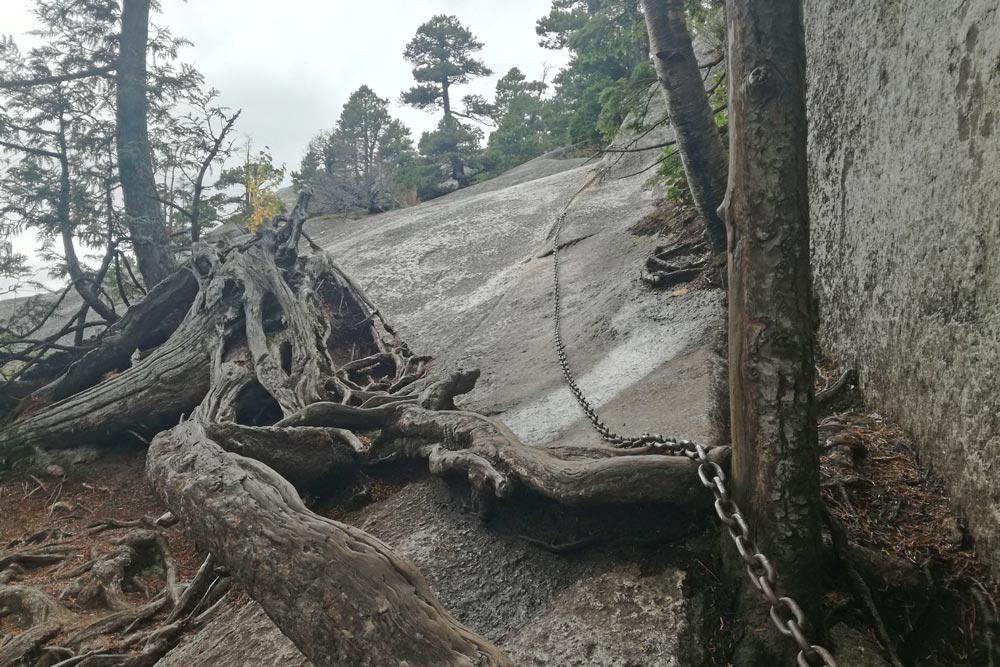
The Stawamus Chief hike outside the village Squamish near Vancouver is named after the massive granite rock ‘The Chief’ you climb during this amazing hike. This huge rock is very famous for rock climbing.
The Chief has three peaks that you can summit during this hike. It is a challenging hike with a total elevation gain of more than 900 meters. The three peaks are separate, so you go down after climbing one peak before you start to go up the next.
The total distance of the hike to all three peaks is about 8 km and takes most people 4 or 5 hours to complete. Getting to the top of each peak is challenging and hikers make use of chains and ladders to scramble to the top of the granite rock in some sections.
The views of Howe Sound and Garibaldi Provincial Park are incredible from the top of the peaks of the Chief. The hike follows the same path up and down. It is possible to only climb the first peak or only peak one and two, which will take a lot less time.
The granite rock gets very slippery when it is wet and it can be dangerous, so this hike is better to do in summer in dry weather. The Chief is right next to Highway 99: only about 55 km from Vancouver and less than 5 km south of Squamish. There are daily buses from Vancouver to Squamish, making it easy to get to from Vancouver.
The Juan de Fuca Trail, Vancouver Island
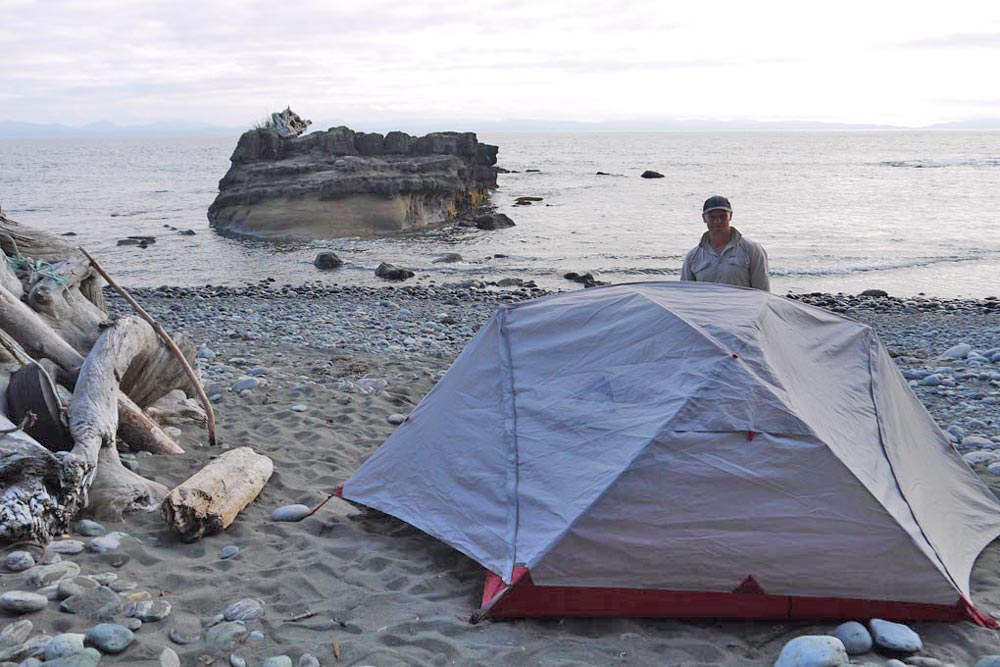
The Juan de Fuca marine trail is a beautiful coastal hiking trail over beaches and forest along the coast of Juan de Fuca provincial park on Vancouver Island.
This challenging hike on Vancouver Island is a backpacking trail and you have to carry all the food, gear, and supplies you need for the duration of the hike.
The total distance of the Juan de Fuca hiking trail is 49 km through dense forest with plenty of hills to conquer. The hiking route starts from China Beach, close to the town Sooke in the south, to Botanical Beach located close to Port Renfrew in the north.
The trail takes an average of 4 days to complete. There are campsites to stay along the way, and no pre-booking is necessary, you can leave the camp fee in a deposit box on site.
Plenty of marine animals can be seen when hiking on the beach; keep in mind to always keep an eye out for bears on the route and feel free to explore the intertidal pools. Bear Beach has beautiful pools filled with barnacles, mussels, anemones, and other interesting animals.
There are several trailheads on the Juan de Fuca trail with car parking making it easy to do day hikes or to hike only a part of the trail. Parkinson Creek, Sombrio Beach, and China Beach are all quick to reach from trailheads, each with car parking.
Doing Vancouver island day hikes along the trail and spending some time on these beaches is great. Sombrio is a very nice beach to come for the weekend. The beach has a beautiful hidden waterfall in the forest and is one of the most popular beaches for surfing on Vancouver Island.
Transport to the Juan de Fuca Trail can be arranged with the West Coast Trail Express from Victoria. To get to Victoria from Downtown Vancouver takes about 3 hours by car and ferry. The ferry trip is beautiful, passing islands (and seeing marine life with a bit of luck!)
To get to Victoria by public transport use the SkyTrain’s Canada Line and bus service to get to the Tsawwassen Ferry Terminal, take a ferry to the Swartz Bay terminal on Vancouver Island, and take bus #70 to downtown Victoria.
The West Coast Trail, Vancouver Island
Famous for being one of the toughest and most beautiful multi-day wilderness hikes in the world, the West Coast Trail hiking route on the west coast of Vancouver Island is an experience pursued by numerous adventurers every year.
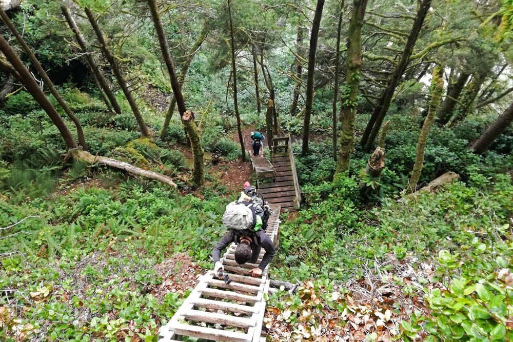
The fauna and flora on this trail is unreal. This 75 km multi-day hike challenges hikers with tough terrain; hours of walking on the sand, pools of mud, and about 70 ladders to climb — with all your gear to boot. It is a 5 to 7 day hike, which requires carrying your tent, supplies, food, and gear for the whole route.
A key difference between this and the Juan de Fuca hike is that you have to complete the entire trail. There are not other trailheads to start or exit on the way.
Part of what makes this trail so special is that the majority of the hike is on miles of extensive, white sandy beaches, and you can pitch your tent on the beach every night!
When not hiking on the sand, the trail goes through spectacular indigenous forest; however, this is where it can get very muddy and tough when it rains.
The wildlife you can see on the West Coast trail is incredible, from terrestrial animals like deer, bears, and wolves in the forest to marine animals like orcas, whales, and dolphins while hiking on the beach.
Only 30 people are allowed to start hiking the West Coast trail per day, so booking this trail early is important. Transport to the West Coast Trail can be arranged from Victoria with the West Coast Trail Express.
The Trans Canada Trail
Also known as The Great Trail, the 24,000 kilometers (15,000 miles) route is the longest recreational trail in the world and stretches over the massive country of Canada connecting the Pacific, Atlantic, and Arctic Oceans.
The complete trail has only been hiked by a few people, taking more than two years of committed full-day daily hiking to complete. The trail is made up of about 400 different sections, and it is said most Canadians live so close to the trail that they can get there within about 30 minutes.
The West Vancouver part of the Trans Canada Trail starts in Horseshoe Bay, along the Seaview Walk, and then splits into an upper and lower trail.
The upper trail across the Upper Forested Lands is good for hiking. Where the Great Trail passes through Vancouver’s Burnaby Mountain Conservation, it connects many different walking routes in the area. In Vancouver, more than 42 km of trails are part of the Great Trail and 24 km of these trails are next to the ocean, either on shoreline pathways or on the seawall.
About the Author
Campbell from South Africa and Alya from Russia have been traveling the world together searching for the best hikes and dives on the planet since the day they met in the Philippines in 2014. A lot has happened on the way, starting their successful travel blog Stingy Nomads, getting married, and they are still traveling!
Pin this Post on Hiking in & Around Vancouver!
Allison Green is a former teacher who has been travel blogging since 2016, visiting 75+ countries in total. She has a Masters in Teaching and a B.A. in English and Creative Writing. As a former educator, she merges her writing and educational experience to encourage ethical, sustainable travel. She has been a speaker at the World Travel Writers Conference and TBEX. Her writing, photography, and podcasting work has appeared in National Geographic, CNN Arabic, CBC Canada, and Forbes, amongst others. When she’s not on the road, she lives in Bangkok, Thailand.