

10 Best Hikes in Tenerife (Guided & Independent Options!)
Tenerife, the largest and most popular of the Canary Islands, is a paradise for nature lovers.
The gorgeous island offers diverse landscapes ranging from black-sand beaches to sky-high mountain peaks and lush forests… all on one single island.
As you explore these stunning landscapes, travelers can find countless hiking trails, with endless natural beauty around every corner.
I traveled to Tenerife twice, in 2022 and 2023, and spent a total of two months on the island.
During my time in Tenerife, my absolute favorite thing to do was discovering new hiking trails.
Since I was visiting in winter, when the weather is pleasant but not usually warm enough for the beach, I spent a lot of time hiking!
I got to walk dozens of trails across Tenerife, and although it’s hard to choose, I’d say my two favorite areas are the Teide National Park and the vibrant laurel forest of the Anaga Rural Park.
In this guide, I’ll share some of my favorite hikes in Tenerife, with options for guided and independent day hikes.
Oh, and I also have guides for hiking in Fuerteventura and Lanzarote, so check those out if you’re visiting more than one Canary Island and want to hike!
Should I Do a Guided or Independent Hike in Tenerife?
When choosing between guided and independent hikes, you’ll want to consider a few factors.
The first thing to consider is how accessible the area you’re looking to explore is.
Although most hiking areas are easy enough to reach by bus, some places have limited connections or are simply too vast to explore on your own on a day hike.
The other aspect to consider is whether you need a permit to hike an area. This mainly applies to the Teide Summit, which is only accessible with a valid permit.
While you could obtain an individual permit, these are limited and hard to acquire unless you plan your hike several months in advance.
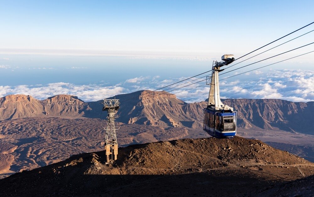
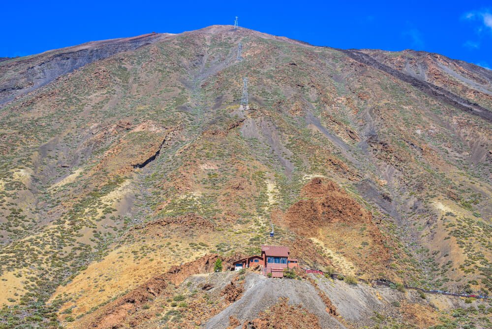
You’ll also likely want to go with the cable car, which brings you from 2,356 meters from the base station to La Rambleta at a whopping 3,555 meters, skipping a hike of over 1,000 meters of high elevation.
It is possible to hike it (starting at Montaña Blanca), but it’s a really long and steep hike only suitable for expert hikers, as the peak of Teide tops out at 3,715 meters / 12,188 — a range where altitude sickness is a definite possibility.
This is where a guided hike comes in handy, as they usually include the permit with the booking, like with Mt. Teide, and sometimes extras like the cable car or additional transportation.
Lastly, consider whether you’re searching for peace and a chance to vibe with nature in solitude, or want to be social and meet other travelers.
If you’re a somewhat experienced hiker and enjoy hitting the trails alone, you’ll find plenty of chances to do just that all over the island.
Joining an organized group hike, on the other hand, offers a great opportunity to socialize and maybe even make some new friends on the island.
Best Guided Hikes in Tenerife
Mount Teide Hiking Tour with Cable Car – Book Here
Hiking Mount Teide is one of the best things to do in Tenerife.
The island’s top attraction is also the highest peak in Spain, so skipping this impressive volcano would also mean missing out on a one-of-a-kind experience.
Fun fact: Mt. Teide is the largest volcano by mass after the Big Island of Hawaii‘s two volcanoes, Mauna Kea and Mauna Loa!
Mount Teide towers over the island from its center and is visible from most of the other Canary Islands.
While you can hike Mount Teide individually, this is actually one of the hikes I recommend doing on an organized tour.
This Mount Teide hiking tour is one of the best options for those looking to hike to Mount Teide’s summit.
This small group tour includes everything, so you won’t have to worry about requesting permits and booking the cable car in advance.
You can join this tour from a pick-up point or even arrange a pick-up at your hotel.
Note that the pick-up service is only available at a few hotels in Los Cristianos, Las Americas, and Costa Adeje, all in Tenerife South.
You’ll travel to Teide National Park in a van and catch the cable car up to Mount Teide.
Last, but not least, you’ll hike the final 170 meters to reach the summit, so you’ll feel like you earned it — and since Teide peaks at over 12,000 feet or 3,715 meters, you’ll feel every step of that 170-meter final climb!
Only permit holders can hike to the summit, so the benefit of this tour is that it includes that permit along with the cable car ride.
After resting and enjoying the view from the summit, you’ll descend and catch the cable car back.
On your way back to Tenerife South, you also have another stop at Roques de Garcia to take in the impressive landscape one more time.
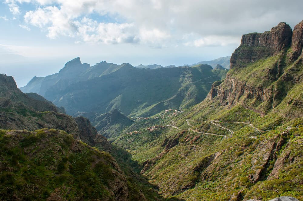
Masca Ravine Guided Tour – Book Here
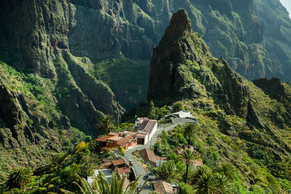
Masca Valley is another popular spot for hiking in Tenerife, and joining a guided tour is the best approach again here.
The Masca Ravine hike is quite difficult, so doing it with a professional guide and other travelers is definitely a good idea.
The meeting point for this tour is directly in the Masca Village, and you’ll have to find your way there on your own.
Since there’s only limited parking options near the village, the best option is going to Masca by bus.
To go by bus, take Line 355: it has departures from Buenavista and Santiago del Teide to Masca.
The hike is just about 10 kilometers (6 miles) out and back — but it’s a challenging one!
You’ll hike downhill in the Masca ravine and back uphill on quite a steep trail with an elevation of roughly 650 meters, so this trail is not for beginners!
That said, going on a guided tour and having a guide along the way will make you feel a lot more comfortable if this trail is at the edge of your comfort zone.
Of course, you’ll want to be sure to have appropriate shoes, plus pack enough water, snacks, and sunscreen.
If you’re up for the challenge, you’ll be rewarded with one of the most spectacular landscapes in Tenerife, hiking through giant forest-covered cliffs and beautiful flora.
Plus, the picturesque village of Masca is a true gem worth discovering!
From start to finish, the hike takes roughly 7 hours, but it’s absolutely worth it!
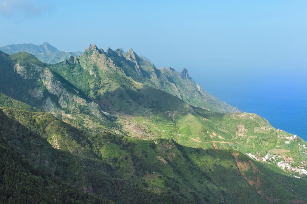
Anaga Rural Park Tour – Book Here
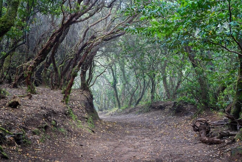
One last hiking area worth exploring with a guided tour is Anaga Rural Park.
This vast, lush laurel forest in the north of Tenerife is the greenest area of the island and provides many hiking trails.
You could easily hike for days in the Anaga Rural Park and still find unique trails.
This Anaga Rural Park tour is the perfect way to experience the highlights of this area with a skilled guide, learn about the native flora and history of the park, and meet other travelers.
You can even request pick-up from locations in the south of Tenerife, a much easier way to reach the park than by bus if you haven’t rented a car in Tenerife.
During this 8-hour hiking tour, you’ll explore the gorgeous laurel forest, enjoy spectacular panoramic views of the northern Tenerife coastline, and stop by charming little villages.
Your knowledgeable guide will tell you all about the geology of the region and local fauna and flora, making the activity fun and educational.
Best Independent Day Hikes in Tenerife
The great thing about Tenerife is that there are buses offering many connections to several hiking areas.
This way, you can reach different hikes of various lengths and difficulty without necessarily needing to join a group tour, even if you don’t have a car.
Here are my favorite day hikes in Tenerife for you to look through — which ones will you add to your trip?
Montaña Chinyero (PR-TF 43)
- Difficulty: Moderate
- Distance: 8.2 km (5.1 miles)
- Time to Complete: 2-3 hours
- Type: Loop
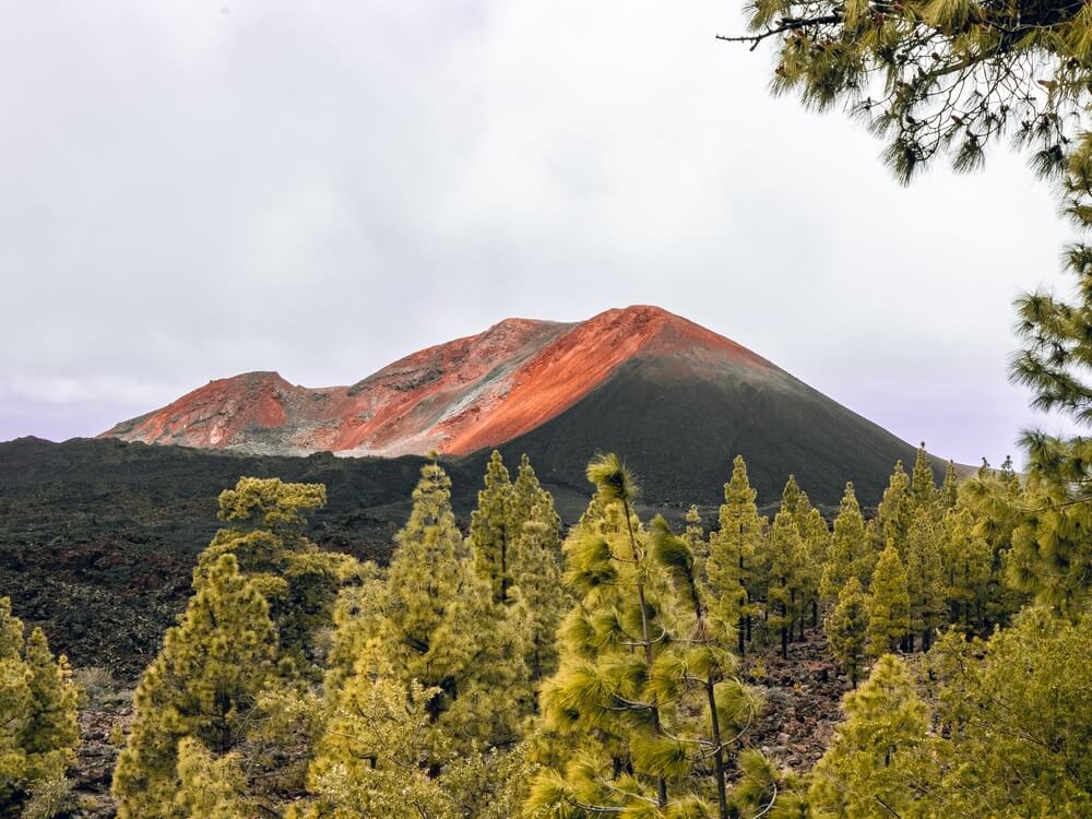
This is one of the most popular hiking trails in Tenerife, located just outside Santiago del Teide.
The loop trail begins in a parking lot on the TF-38 road connecting Santiago del Teide to the Teide National Park.
You’ll also find it marked on Google Maps as Sendero del Chinyero, so it’s easy to know where to start!
This easy-to-moderate trail offers spectacular views of the volcanic landscape around the Chinyero Volcano, one of the island’s youngest volcanoes whose most recent eruption was in 1909.
The 8-kilometer hike is part of the longer PR-TF 43 trail that begins in Garachico, on the northern coast of Tenerife, covering a total distance of 31 kilometers (over 19 miles).
You can easily complete the trail in about three hours with breaks.
If you’re up for more of a challenge, you can also take a 26-kilometer loop hike from Santiago del Teide, with stops at Chinyero, Montaña de las Flores, and Montaña Bilma.
However, this trail takes upward of 8 hours, so it’s only for really experienced hikers!
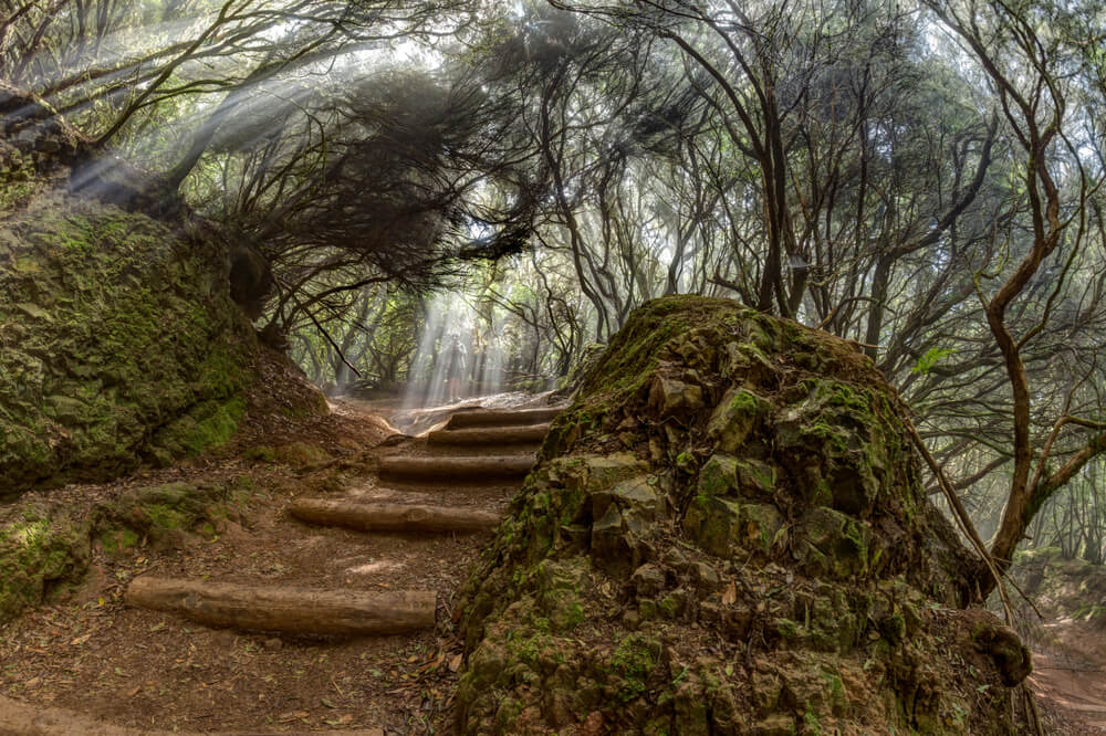
Sendero El Bosque de los Enigmas
- Difficulty: Moderate
- Distance: 5 km (3.1 miles)
- Time to Complete: 1.5-2 hours
- Type: Loop
AllTrails marks this as a moderate hike, but if I’m being honest, I found it pretty easy, and it only has an elevation of 200 meters.
The main challenge of this hike is likely the unpredictable weather as you walk through the lush laurel forest!
The Bosque de los Enigmas hike begins and ends at Cruz del Carmen, a popular departure spot for other trails within the Anaga Rural Park.
Here, you can also admire the stunning views from Mirador Cruz del Carmen.
The hike takes less than two hours with breaks. Roughly halfway through, you can stop to catch your breath and enjoy the view from Mirador de Zapata.
Given how short and easy this hike is, I recommend pairing it with one of the other short hikes that start from Cruz del Carmen.
Sendero de los Sentidos is a short loop trail that takes less than one hour and offers a peaceful walk through the forest with a couple of viewpoints along the way.
You can easily reach Cruz del Carmen by car or by bus 273 from Intercambiador la Laguna.
As an added bonus, this is one of the easiest hiking spots to reach without a car in Tenerife.
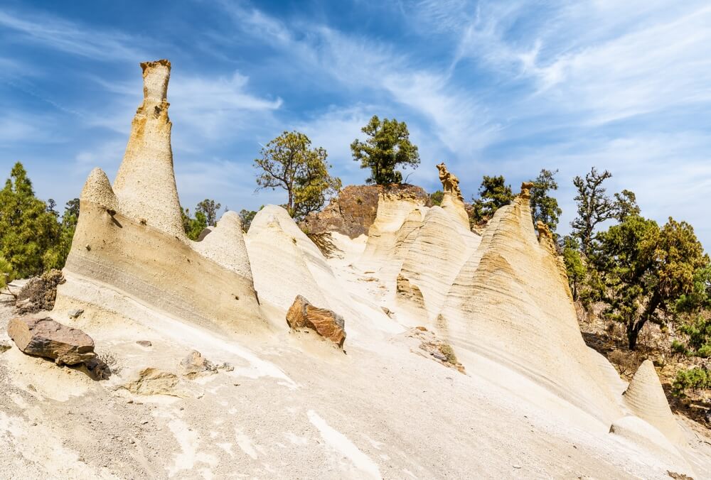
Paisaje Lunar (PR-TF 72)
- Difficulty: Hard
- Distance: 13.4 km (8.3 miles)
- Time to Complete: 4-6 hours
- Type: Loop
This is one of my favorite trails in Tenerife, thanks to its incredible views, which are some of the most spectacular on the island!
The name of this trail, which translates to Lunar Landscape, is surprisingly accurate, as you’ll notice once you reach its highlight.
The lunar landscape is quite a small area, but it’s surreal, especially after walking several kilometers through pine forests and mountain trails.
Once you get there, you’ll see several beige conical shapes emerging from the volcanic slopes, creating fascinating formations.
This trail is marked as hard, but I’d say it’s only moderately challenging, with some ups and downs… but it is long, so depending on your fitness, you may find it tiring.
You should, however, be prepared with layers and sunscreen, as most of the trail provides no shade.
The loop trail begins in the charming town of Vilaflor, which you can reach by bus 482 from Los Cristianos.
Since the hike can take up to six hours, depending on how many times you stop and how long you stay at Paisaje Lunar, I recommend heading to Vilaflor early in the morning to get a head start!
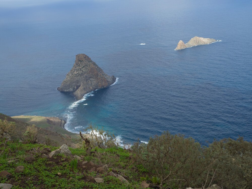
Las Vueltas de Taganana
- Difficulty: Hard
- Distance: 8 km (5 miles)
- Time to Complete: 4-5 hours
- Type: Loop
The area around Taganana offers a few hiking trails, each more picturesque than the last.
The town of Taganana is delightful, so I recommend spending some time exploring it while you’re here.
It won’t take more than half an hour to wander around the small gathering of houses overlooking the ocean and the imposing Roque de las Animas.
Las Vueltas de Taganana is quite a challenging hike, with an elevation gain of over 700 meters, so you should take it slow, bring sufficient water and snacks, apply (and re-apply!) sunscreen, and take lots of breaks.
Although the trail is difficult, you won’t be disappointed by the impressive views over the Anaga Massif!
A word of warning: the weather can change suddenly in this area, from sunny and hot to rainy and windy.
I recommend dressing in layers and having a waterproof jacket and good hiking boots.
If you’re traveling without a car, you can get to Taganana by bus 946 from Santa Cruz de Tenerife.
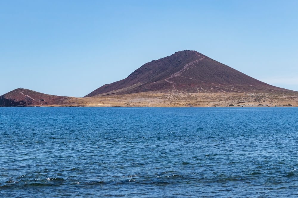
Montaña Roja
- Difficulty: Moderate
- Distance: 4.7 km (2.9 miles)
- Time to Complete: 1.5-2 hours
- Type: Loop
The south of Tenerife isn’t exactly known for its hiking trails, but Montaña Roja is a lovely exception.
The profile of this mountain, sitting on the southern shore of Tenerife, can be seen from many points all over the island.
This short trail is a great activity to combine with a relaxing afternoon at one of the gorgeous nearby beaches, Playa del Médano or Playa de la Tejita (pictured), one on each side of the “Red Mountain.”
Ideally, you’ll want to start your hike either early in the morning or late in the afternoon to avoid the hottest hours.
The most challenging aspect of this hike is the heat, since you won’t have any shade the whole way up the mountain.
At the same time, you can experience strong winds when you finally reach the top, so do bring a jacket or sweater.
At the top, you can enjoy sweeping coastal views that will more than repay your efforts.
The official trail start is La Tejita Beach Parking Lot, but you can also start from Parking Montaña Roja or even from El Médano, as I did.
If you don’t have a car, buses 470, 410, and 483 stop at La Tejita.
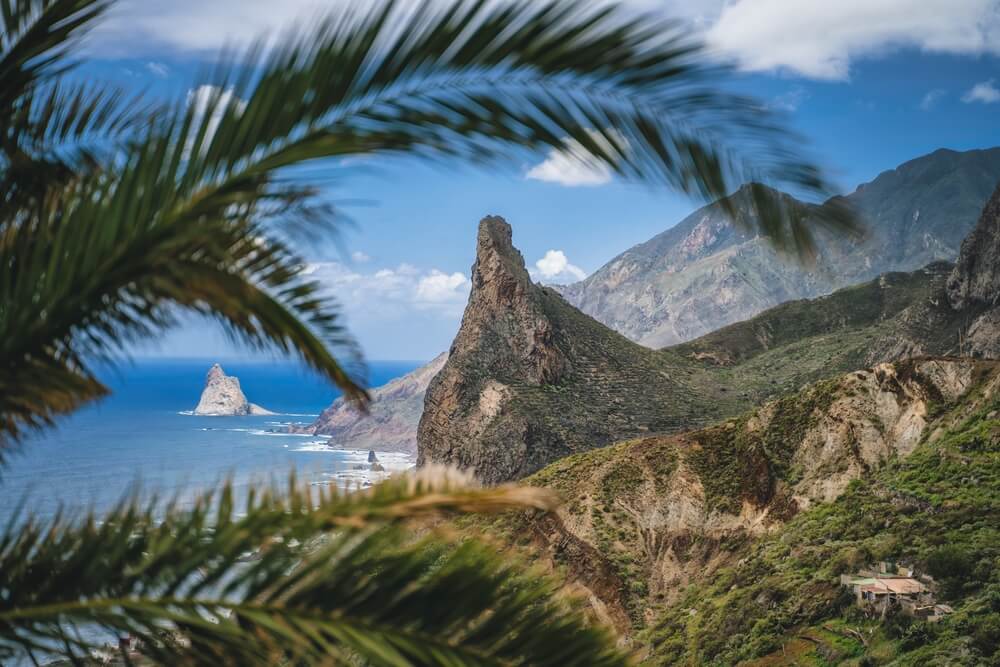
Benijo – Cruz del Draguillo (PR-TF 6.3)
- Difficulty: Hard
- Distance: 5.1 km (3.2 miles)
- Time to Complete: 2-3 hours
- Type: Loop
If you enjoy trails with stunning panoramic coastal views, consider the Benijo to Cruz del Draguillo trail.
This loop trail begins in Benijo, a small coastal town on the northern coast of Tenerife that you can easily reach by bus 946 from Santa Cruz.
The beaches in this area are some of the most spectacular on the island, in my opinion, boasting spectacular rock formations and black sand.
The hike allows you to admire the dramatic coastline and the lush vegetation of the Anaga Rural Park.
One of the biggest challenges of this hike is the elevation!
As usual for this area, dressing in layers is recommended as it can get windy at higher elevations.
The hike is close to other wonderful places you can visit, like the charming Almáciga, Roque de las Bodegas, and Taganana.
After the hike, you can stretch out and relax on a nearby beach, like Playa de Benijo, Playa de Almáciga, or Playa del Roque de las Bodegas.
Roques de García
- Difficulty: Moderate
- Distance: 3.5 km (2.2 miles)
- Time to Complete: 1-1.5 hours
- Type: Loop
Lastly, if you want to explore the Teide National Park on your own instead of with a group, you can reach the area by bus and enjoy some of the many trails around the park.
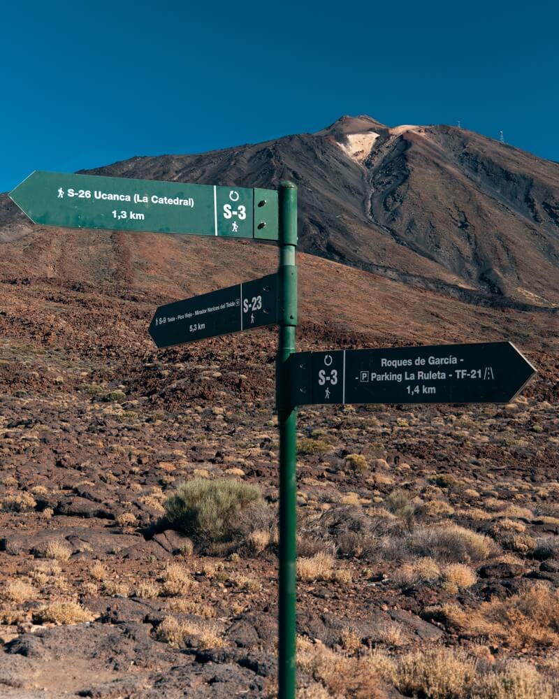
One of the most popular and picturesque hiking trails is the loop of Roques de García.
This trail offers stunning views of the peak of the Teide and impressive volcanic rock formations like La Catedral, Roque Chinchado, and Roques Blanco.
This short trail begins close to Parador Las Cañadas del Teide, one of the main parking lots in the Teide National Park.
However, since this is a very accessible trail, you can expect it to be quite crowded, especially right at the start!
However, you can also explore other short nearby trails to admire the gorgeous volcanic landscape, many of which are less crowded.
Head to the Cañada Blanca Visitor Center and check out the trails departing from there to see what feels right to you.
You can reach Parador Las Cañadas del Teide by bus 342 from Costa Adeje or Los Cristianos and 348 from Puerto de la Cruz or La Orotava.
Expert Tip: Note that line 348 was suspended after recent fires in Tenerife (August 2023), so check whether it has resumed service by the time you visit!

Roxana is a Romanian-born freelance travel writer who has lived in Italy for over 15 years. She has a Master’s in Journalism and a Bachelor’s in Film Studies, and she studied at Università degli Studi di Roma Tre. Besides her native Romania, Roxana has lived in Rome, Lisbon, and Berlin, and she has traveled through much of Europe in search of hidden gems, history, and culture.